Presentación de PowerPoint - lorenzo-borselli.eu · taludes en el sistema solar: desde Marte, Luna...
63
Modelado de estabilidad de taludes en el sistema solar: desde Marte, Luna y Ceres hasta volcanes y micro-taludes Lorenzo Borselli Instituto de Geología Universidad Autónoma de San Luis Potosí Av. M. Nava No 5, Zona Universitaria, San Luis Potosí, 78240, Mexico [email protected] http://www.lorenzo-borselli.eu Campus de Geociencias UNAM, Queretaro -13-04-2016
Transcript of Presentación de PowerPoint - lorenzo-borselli.eu · taludes en el sistema solar: desde Marte, Luna...

Modelado de estabilidad de taludes en el sistema solar: desde Marte, Luna y Ceres
hasta volcanes ymicro-taludes
Lorenzo BorselliInstituto de Geología
Universidad Autónoma de San Luis Potosí Av. M. Nava No 5, Zona Universitaria,
San Luis Potosí, 78240, [email protected]
http://www.lorenzo-borselli.eu
Campus de Geociencias UNAM, Queretaro -13-04-2016
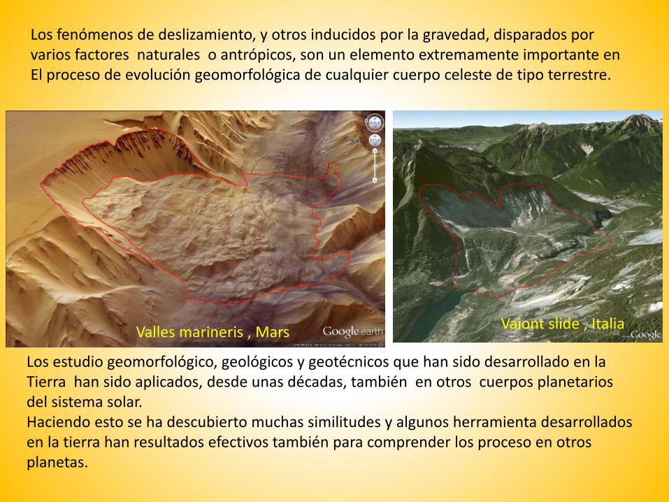
Los fenómenos de deslizamiento, y otros inducidos por la gravedad, disparados por varios factores naturales o antrópicos, son un elemento extremamente importante en El proceso de evolución geomorfológica de cualquier cuerpo celeste de tipo terrestre.
Los estudio geomorfológico, geológicos y geotécnicos que han sido desarrollado en la Tierra han sido aplicados, desde unas décadas, también en otros cuerpos planetarios del sistema solar. Haciendo esto se ha descubierto muchas similitudes y algunos herramienta desarrollados en la tierra han resultados efectivos también para comprender los proceso en otros planetas.
Vaiont slide , ItaliaValles marineris , Mars
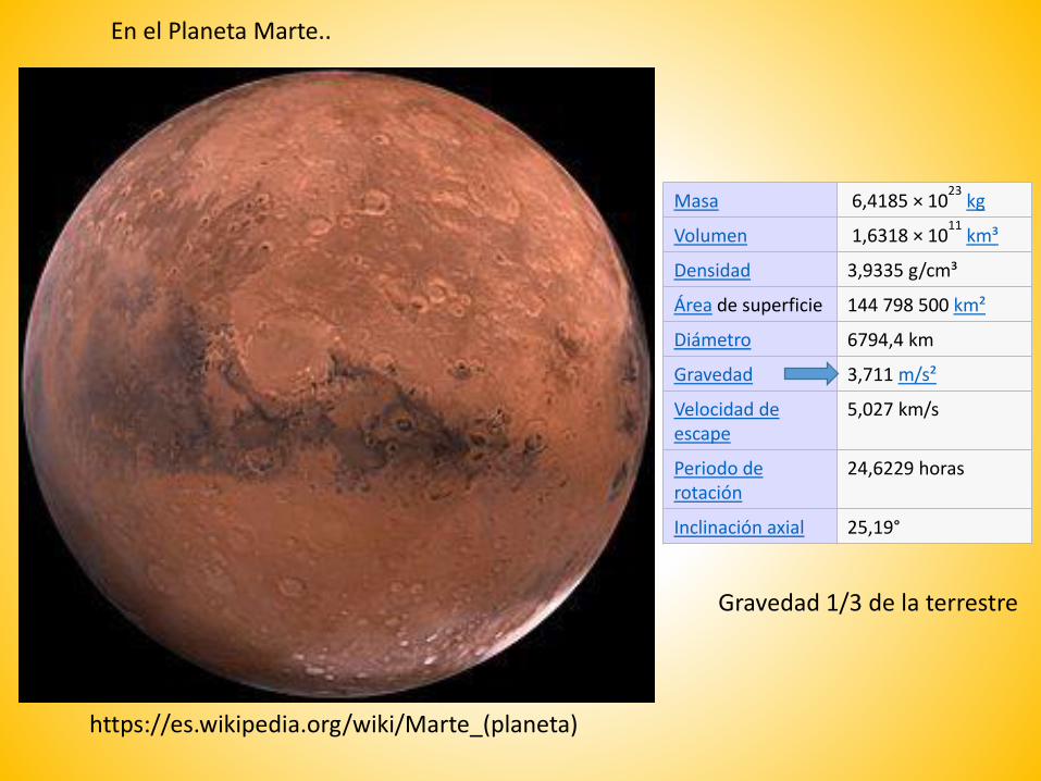
En el Planeta Marte..
https://es.wikipedia.org/wiki/Marte_(planeta)
Masa 6,4185 × 10²³
kg
Volumen 1,6318 × 10¹¹
km³
Densidad 3,9335 g/cm³
Área de superficie 144 798 500 km²
Diámetro 6794,4 km
Gravedad 3,711 m/s²
Velocidad de escape
5,027 km/s
Periodo de rotación
24,6229 horas
Inclinación axial 25,19°
Gravedad 1/3 de la terrestre
Valles marineris
OphirChasma
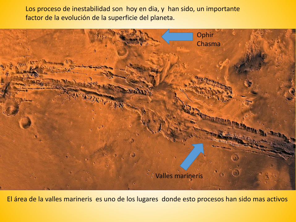
Los proceso de inestabilidad son hoy en dia, y han sido, un importante factor de la evolución de la superficie del planeta.
El área de la valles marineris es uno de los lugares donde esto procesos han sido mas activos
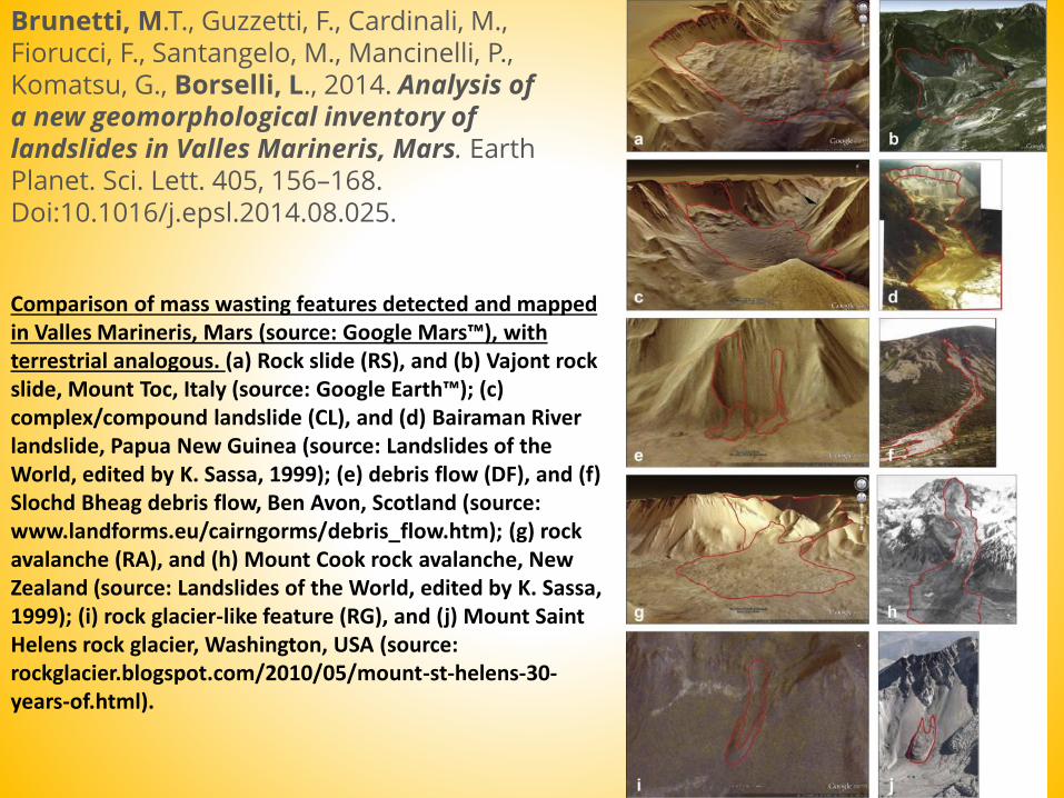
Brunetti, M.T., Guzzetti, F., Cardinali, M., Fiorucci, F., Santangelo, M., Mancinelli, P., Komatsu, G., Borselli, L., 2014. Analysis of a new geomorphological inventory of landslides in Valles Marineris, Mars. EarthPlanet. Sci. Lett. 405, 156–168. Doi:10.1016/j.epsl.2014.08.025.
Comparison of mass wasting features detected and mappedin Valles Marineris, Mars (source: Google Mars™), withterrestrial analogous. (a) Rock slide (RS), and (b) Vajont rock slide, Mount Toc, Italy (source: Google Earth™); (c) complex/compound landslide (CL), and (d) Bairaman Riverlandslide, Papua New Guinea (source: Landslides of theWorld, edited by K. Sassa, 1999); (e) debris flow (DF), and (f) Slochd Bheag debris flow, Ben Avon, Scotland (source: www.landforms.eu/cairngorms/debris_flow.htm); (g) rock avalanche (RA), and (h) Mount Cook rock avalanche, New Zealand (source: Landslides of the World, edited by K. Sassa, 1999); (i) rock glacier-like feature (RG), and (j) Mount Saint Helens rock glacier, Washington, USA (source: rockglacier.blogspot.com/2010/05/mount-st-helens-30-years-of.html).

Brunetti et al. 2014.
Legend: (1) landslide scarp (source area). (2) Deposit of slide, including rock
slides (RS), complex and compound failures (CL). Relative age shown by different
shades of colour, from older (light) to younger (darker). (3) Deposit of rock
avalanche (RA). (4) Debris flow (DF), including debris avalanches and shallow
debris slides. (5) Rock glacier-like features (RG). (6) Talus. (7) Bedrock. (8) Rock
cliff. (9) Surface trace of trench. (10) Position of profiles used in slope stability
analysis
a) and (b) Maps showing
multiple generations of slope
failures in a portion of the study
area. Purple contours are
failures older than the green
(younger) and the blue
(youngest) landslides.
Background shows HRSC
mosaic (∼15 m/pixel) draped on
MOLA DEM (Christensen et al.,
2004).
Brunetti et al. 2014.

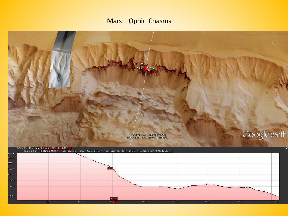
Mars – Ophir Chasma
40 km
Reactivation
Mars – Ophir Chasma
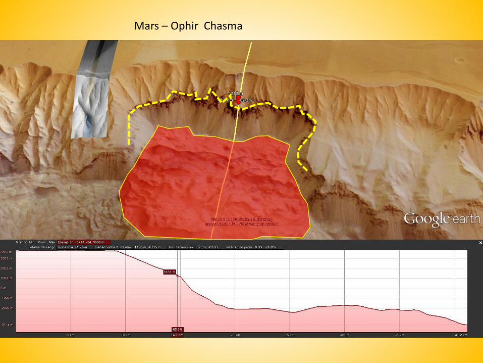
Mars – Ophir Chasma

http://www.irpi.cnr.it/en/focus/frane-nel-sistema-solare-2/
Examples of rock slides on the Moon (scarps in purple and deposits in green) and Mercury (scarps in red and deposits in light blue).
Mercury
Moon
Brunetti MT, Xiao Z, Komatsu G, Peruccacci S, Guzzetti F. 2015. Large rock slides in impact craters on the Moon and Mercury. Icarus 260: 289–300. DOI: 10.1016/j.icarus.2015.07.014.
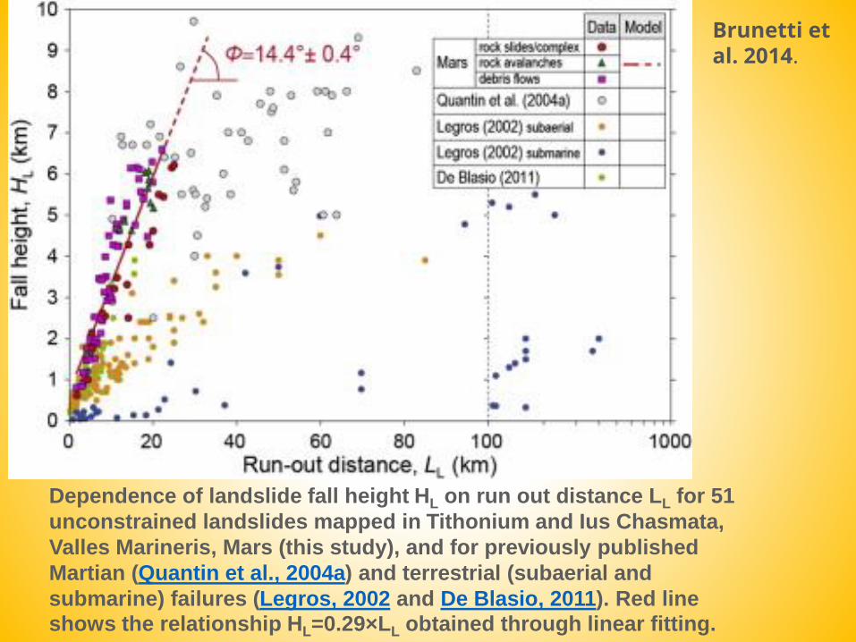
Dependence of landslide fall height HL on run out distance LL for 51
unconstrained landslides mapped in Tithonium and Ius Chasmata,
Valles Marineris, Mars (this study), and for previously published
Martian (Quantin et al., 2004a) and terrestrial (subaerial and
submarine) failures (Legros, 2002 and De Blasio, 2011). Red line
shows the relationship HL=0.29×LL obtained through linear fitting.
Brunetti et al. 2014.

Dependence of landslide volume VL on landslide area AL for 49 landslides mapped in Tithoniumand Ius Chasmata, Valles Marineris, Mars. Red dots show unconstrained landslides and yellow dots show landslides constrained by local topographic setting. Red line shows equation View the MathML source obtained though robust linear fitting. Solid and dashed blue lines, and green lines are similar relationships for terrestrial landslides (Guzzetti et al., 2009 and Larsen et al., 2010). Box plots show statistics of AL (right) and VL (top) for landslides in the VM.
Brunetti et al. 2014.
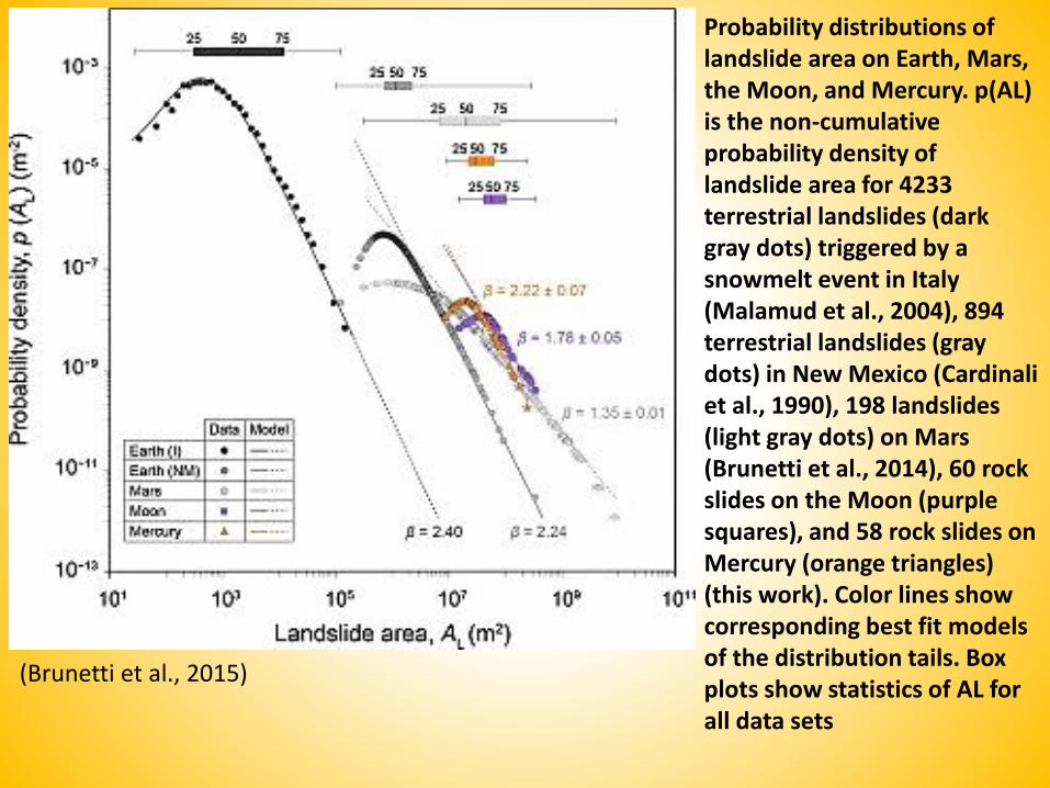
Probability distributions of landslide area on Earth, Mars, the Moon, and Mercury. p(AL) is the non-cumulative probability density of landslide area for 4233 terrestrial landslides (dark gray dots) triggered by a snowmelt event in Italy (Malamud et al., 2004), 894 terrestrial landslides (gray dots) in New Mexico (Cardinaliet al., 1990), 198 landslides (light gray dots) on Mars (Brunetti et al., 2014), 60 rock slides on the Moon (purple squares), and 58 rock slides on Mercury (orange triangles) (this work). Color lines show corresponding best fit models of the distribution tails. Box plots show statistics of AL for all data sets
(Brunetti et al., 2015)

Results of slope stability
analyses performed along
two representative slopes in
Tithonium Chasma (left
charts) and Ius Chasma
(right charts). (a) Dry slope
and no external forcing. (b)
Fully saturated slope
(vertical blue bar) and no
external forcing. (c) Dry
slope and external seismic
forcing (black arrow). (d)
Fully saturated slope and
external seismic forcing
(vertical blue bar and black
arrow). Each chart shows
ten sliding surfaces with the
smallest computed Factor of
Safety (FS) obtained
adopting a Limit Equilibrium
Method approach. Blue lines
show sliding surfaces with
FS > 1 (stable conditions).
Red lines show sliding
surfaces with FS ≤ 1
(unstable conditions). Green
lines show topographic profiles
Slope stability analysisBy SSAP software:www.ssap.eu
Brunetti
et al. 2014.
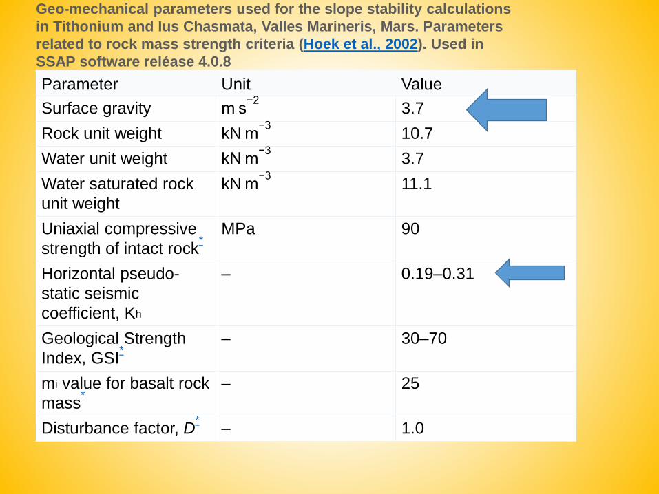
Parameter Unit Value
Surface gravity m s−2
3.7
Rock unit weight kN m−3
10.7
Water unit weight kN m−3
3.7
Water saturated rock
unit weight
kN m−3
11.1
Uniaxial compressive
strength of intact rock*
MPa 90
Horizontal pseudo-
static seismic
coefficient, Kh
– 0.19–0.31
Geological Strength
Index, GSI*
– 30–70
mi value for basalt rock
mass*
– 25
Disturbance factor, D*
– 1.0
Geo-mechanical parameters used for the slope stability calculations
in Tithonium and Ius Chasmata, Valles Marineris, Mars. Parameters
related to rock mass strength criteria (Hoek et al., 2002). Used in
SSAP software reléase 4.0.8
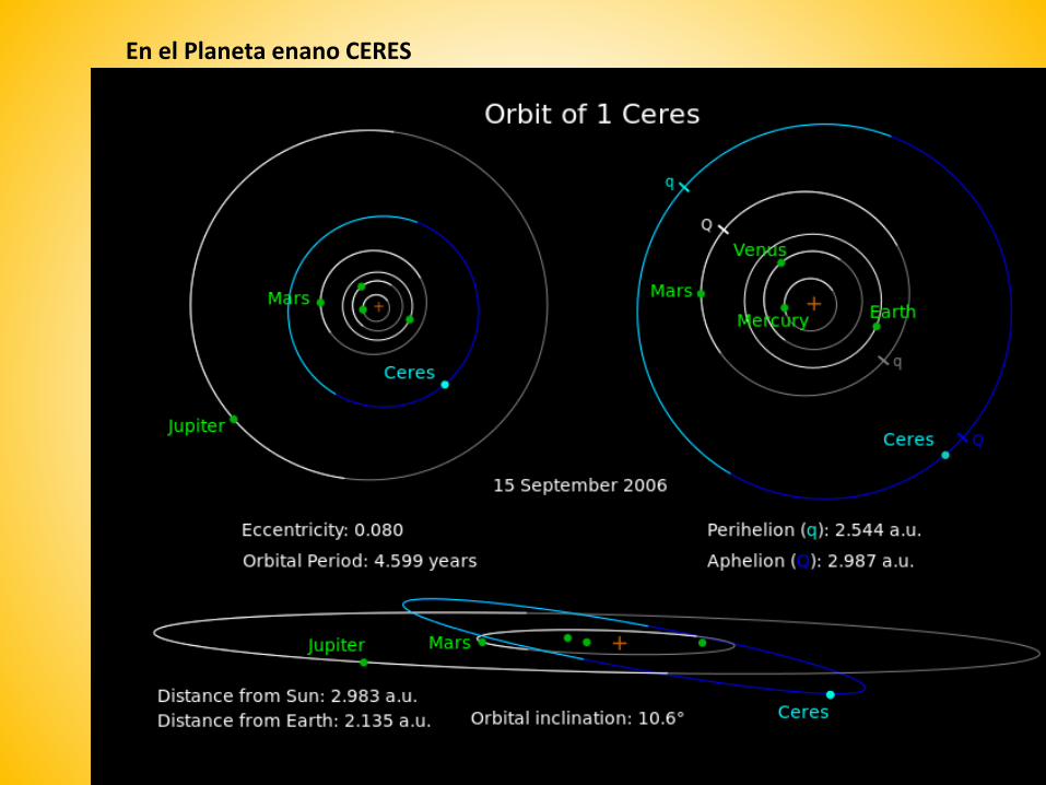
En el Planeta enano CERES
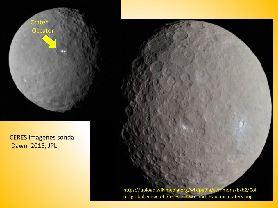
https://upload.wikimedia.org/wikipedia/commons/b/b2/Color_global_view_of_Ceres_-_Oxo_and_Haulani_craters.png
CERES imagenes sondaDawn 2015, JPL
CraterOccator
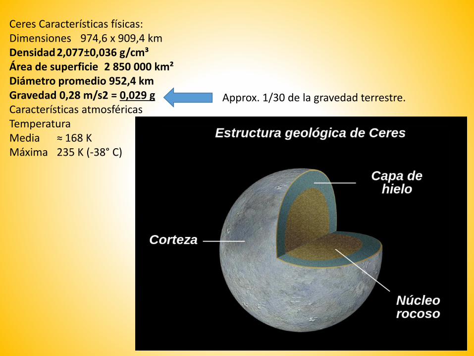
Ceres Características físicas:Dimensiones 974,6 x 909,4 kmDensidad2,077±0,036 g/cm³Área de superficie 2 850 000 km²Diámetro promedio 952,4 kmGravedad 0,28 m/s2 = 0,029 gCaracterísticas atmosféricasTemperaturaMedia ≈ 168 KMáxima 235 K (-38° C)
Approx. 1/30 de la gravedad terrestre.

https://upload.wikimedia.org/wikipedia/commons/b/b3/Ceres_RC2_Bright_Spot.jpg
CraterOccator

Image by http://www.jpl.nasa.gov/spaceimages/details.php?id=PIA19889
Occator crater – Ceres
Approx 92 km
Next zoom
Aunque los planetologos son mas interesados a los probable domos de hielo en el centro del cráter..
Pero Es igualmente interesante lo que pasa en la parte oeste del mismo crater

Images by http://www.jpl.nasa.gov/spaceimages/details.php?id=PIA19889Occator cráter- detalle – Ceres
Accumulacion de los deslizamientoCon hummoks
Corona de deslizamiento
Volcanes terrestresY sus inestabilidades
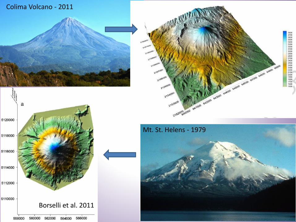
Colima Volcano - 2011
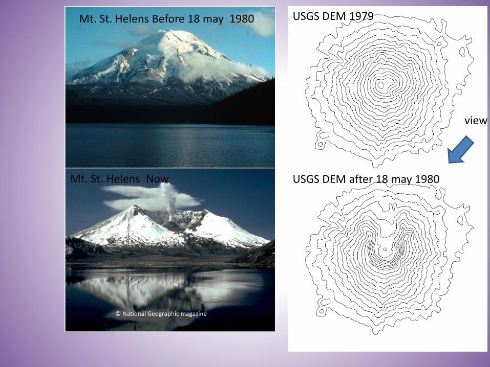
Mt. St. Helens - 1979
Borselli et al. 2011
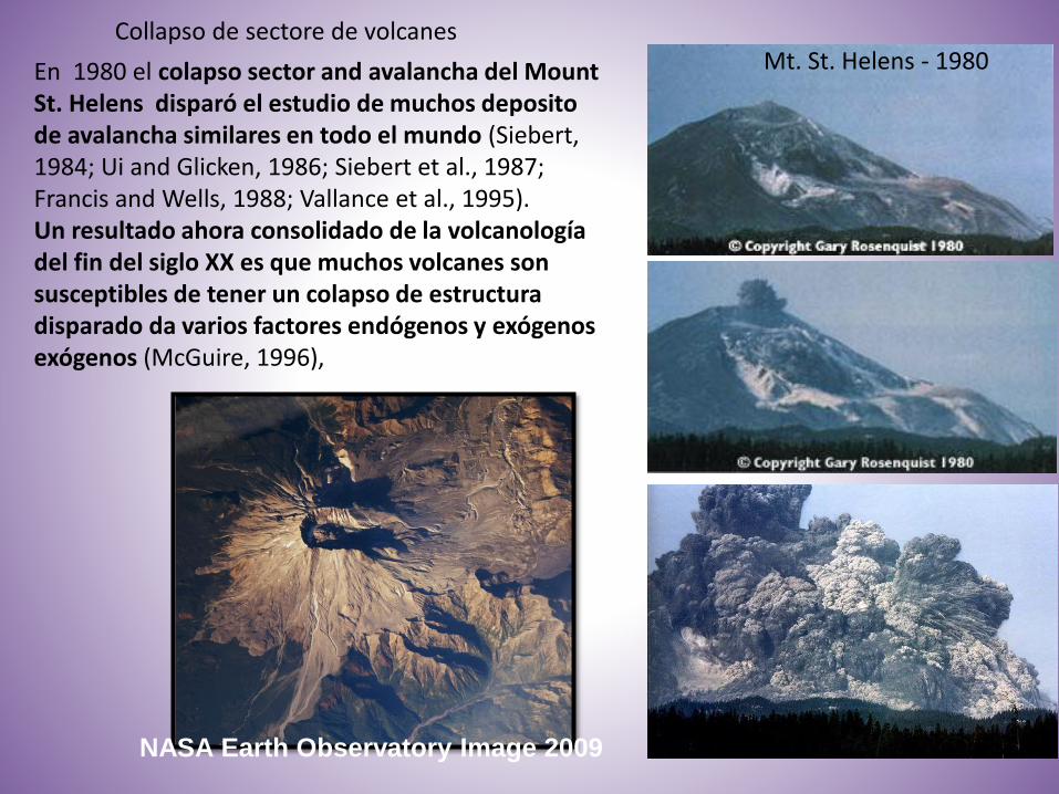
Collapso de sectore de volcanes
NASA Earth Observatory Image 2009
En 1980 el colapso sector and avalancha del Mount St. Helens disparó el estudio de muchos depositode avalancha similares en todo el mundo (Siebert, 1984; Ui and Glicken, 1986; Siebert et al., 1987; Francis and Wells, 1988; Vallance et al., 1995).Un resultado ahora consolidado de la volcanología del fin del siglo XX es que muchos volcanes son susceptibles de tener un colapso de estructura disparado da varios factores endógenos y exógenos exógenos (McGuire, 1996),
Mt. St. Helens - 1980
Colapso de sector de volcanes: causa de disparo
La inestabilidad de un edificio volcánico puede ser causada por muchos factores:• intrusión magmática directa en el edificio (actividad de tipo Bezymianny,
Gorshkov de 1962 Día, 1996; Elsworth y Voight, 1996),• deposición de depósitos piroclásticos voluminosos en pendientes muy
elevadas (Maguire, 1996),• procesos hydromagmáticos (Dzurisin, 1998),• actividad phreatomagmatic (actividad de tipo Bandai, Moriya, 1980).• Actividad tectónica y fallas (McGuire, 1996; Siebert, 1984)• Terremoto (Keefer, 1984)• collapso gravitacionales pueden ocurrir en respuesta a un debilitamiento
progresivo de un edificio.Otros mecanismos de activación incluyen explosiones freáticas , precipitaciones extremas por huracanes (colapso en el volcán Casita en Nicaragua en 1998, Sheridan et al., 1999;. Scott et al, 2005).

Una nueva tecnica de studio que se aplica a stratolcanes A recently developed technique of analysis applied to stratovolcanoes by Borselli et al. (2011)*, para evaluar el grqado de inestabilidades de edificios volcanicos.
*BORSELLI L., CAPRA L., SAROCCHI D., De La CRUZ-REYNA S. (2011). Flank collapse scenarios at Volcán de Colima, Mexico: a relative instability analysis. Journal of Volcanology and Geothermal Research. 208:51–65.
La nueva técnica combina tres metodologías :• 1) slope stability by advanced limit equilibrium analysis (ALEM) of multiple
sectors on the volcano using SSAP 4.0 (Slope Stability Analysis Software, Borselli 2011) which include fluid internal overpressure or progressive dissipation (Borselli et al. 2011), and rock mass strength criteria (Hoek et al. 2002,2006) for local, stress state dependent, shear strength;
• 2) the analysis of relative mass/volume deficit in the volcano structure, made using the new VOLCANOFIT 2.0 software (Borselli et al.2011);
• 3) Statistical analysis of major flank debris avalanche ages in the last 20,000 BP, using stochastic arithmetic methods (Vignes, 1993), and calculating the mean time of recurrence of them.
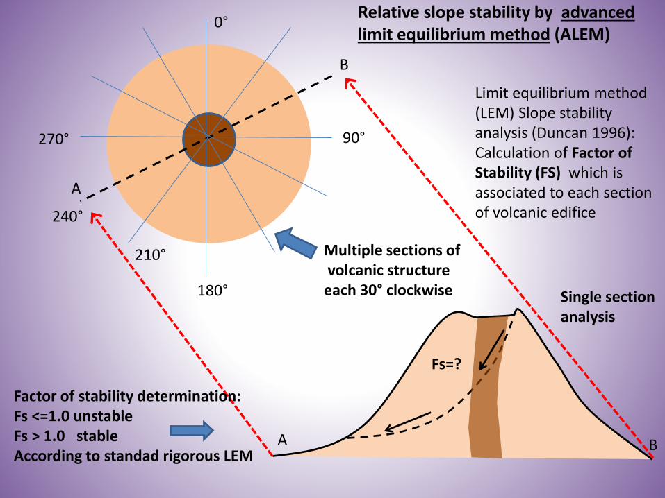
Relative slope stability by advanced limit equilibrium method (ALEM)
Fs=?
A B
B
A
240°
0°
180°
90°
Multiple sections ofvolcanic structure
each 30° clockwise
Limit equilibrium method (LEM) Slope stability analysis (Duncan 1996):Calculation of Factor of Stability (FS) which is associated to each sectionof volcanic edifice
Factor of stability determination:Fs <=1.0 unstableFs > 1.0 stableAccording to standad rigorous LEM
Single section analysis
210°
270°
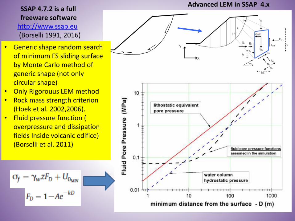
Advanced LEM in SSAP 4.x
http://www.ssap.eu(Borselli 1991, 2016)
SSAP 4.7.2 is a full freeware software
• Generic shape random search of minimum FS sliding surface by Monte Carlo method of generic shape (not only circular shape)
• Only Rigorouus LEM method • Rock mass strength criterion
(Hoek et al. 2002,2006).• Fluid pressure function (
overpressure and dissipation fields Inside volcanic edifice) (Borselli et al. 2011)

Borselli & Sarocchi – “Flank collapse and new relative instability analysis techniques..” ,GSA – Cordilleran , Queretaro 30/3/2012
ALEM analysis application toVolcan de Fuego, Colima, MX(Approx 3880 m a.s.l. )
Volcan de Fuego, Colima (november2011)W view
Saucedo et al. 2010

Volcan de fuegoColima, MX
Selected area for analysis
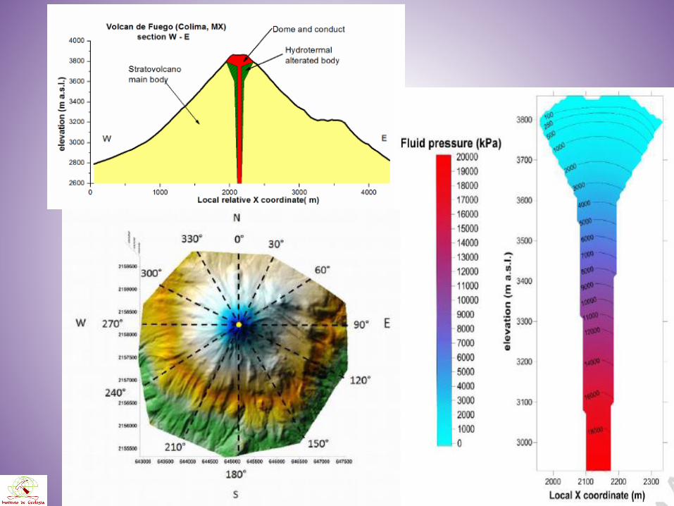

The advanced Limit equilibrium method (ALEM) and Relative instability analysisScenarios and mechanical parameters

Borselli & Sarocchi – “Flank collapse and new relative instability analysis techniques..” ,GSA – Cordilleran , Queretaro 30/3/2012
Final results colima with ALEM

The Relative stability index
The sector with minimun relative stability is W-SW flank(between 270° and 210° )
(Borselli et al. 2011)

Volcanofit 2.0WWW. VOLCANOFIT.ORG
VOLCANOID SURFACE OF REVOLUTION
ALTERNATIVE VOLCANOID’S GENERATRIX
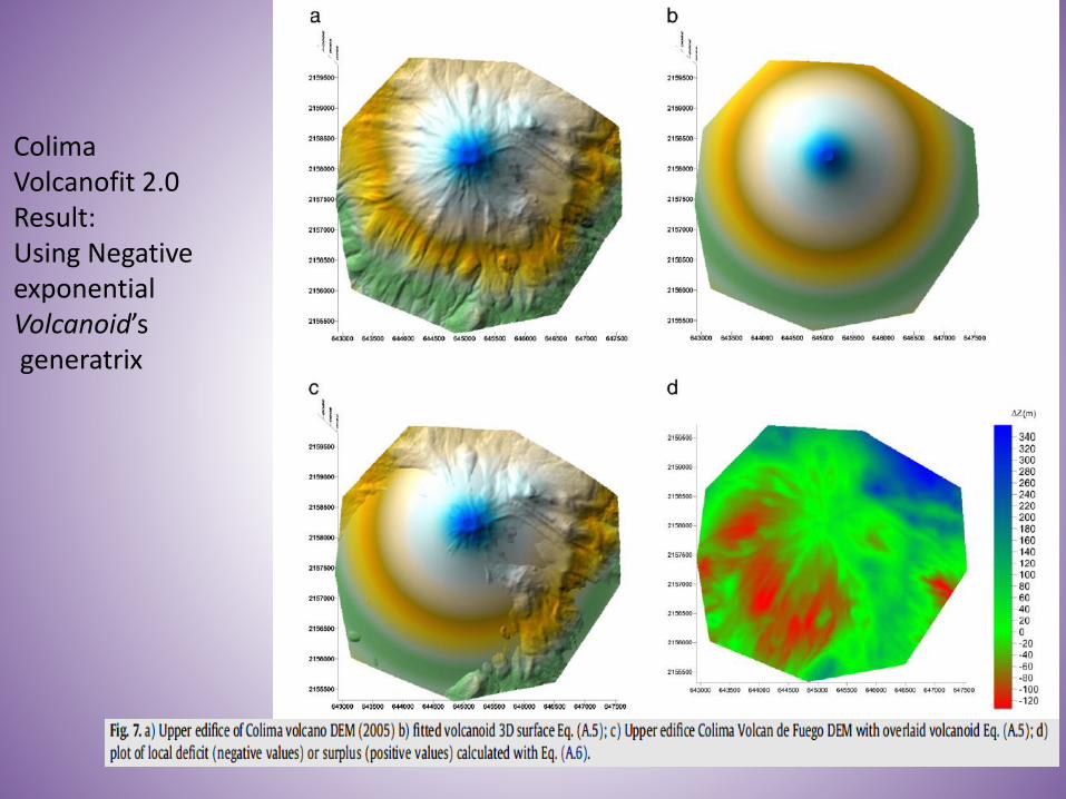
ColimaVolcanofit 2.0Result: Using Negative exponentialVolcanoid’sgeneratrix
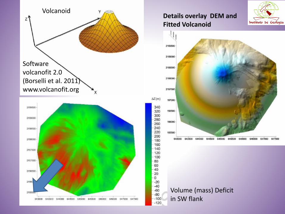
VolcanoidDetails overlay DEM and Fitted Volcanoid
Volume (mass) Deficit in SW flank
Software volcanofit 2.0(Borselli et al. 2011) www.volcanofit.org
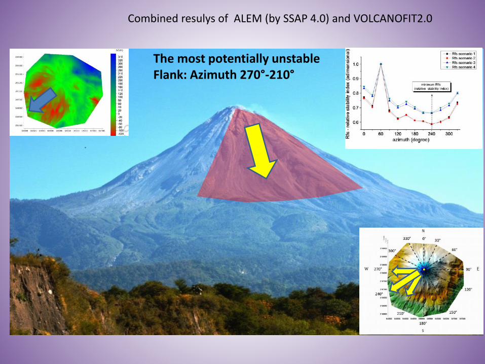
The most potentially unstableFlank: Azimuth 270°-210°
Combined resulys of ALEM (by SSAP 4.0) and VOLCANOFIT2.0
© National Geographic magazine
Mt. St. Helens Before 18 may 1980 USGS DEM 1979
USGS DEM after 18 may 1980Mt. St. Helens Now
view

Mt st. helens 1979 DTMAnalysed by VOLCANOFIT 2.0(Borselli et al. 2011)
© National Geographic magazine

NA
SA
Eart
h O
bs
erv
ato
ry I
mag
e 2
009
DTM by University of Washington, Earth and Space science, 2010. http://rocky.ess.washington.edu/data/raster/thirtymeter/mtsthelens/OldMtStHelens.zip
From Hausback and Swanson (1990)
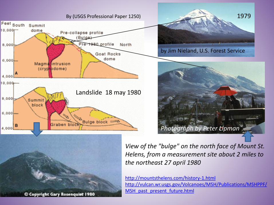
By (USGS Professional Paper 1250)
View of the "bulge" on the north face of Mount St. Helens, from a measurement site about 2 miles to the northeast 27 april 1980
http://mountsthelens.com/history-1.htmlhttp://vulcan.wr.usgs.gov/Volcanoes/MSH/Publications/MSHPPF/MSH_past_present_future.html
by Jim Nieland, U.S. Forest Service
Photograph by Peter Lipman
1979
Landslide 18 may 1980
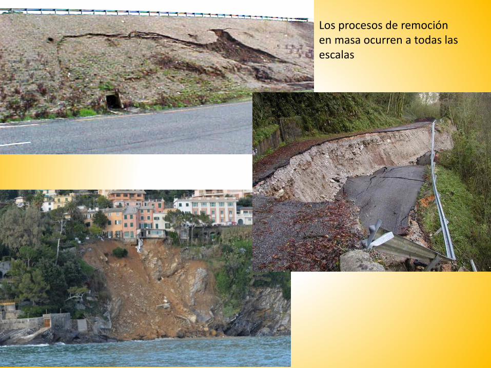
Los procesos de remoción en masa ocurren a todas las escalas
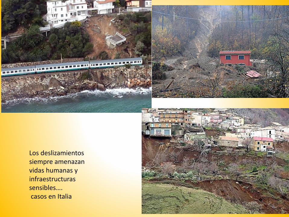
Los deslizamientos siempre amenazan vidas humanas y infraestructuras sensibles….casos en Italia
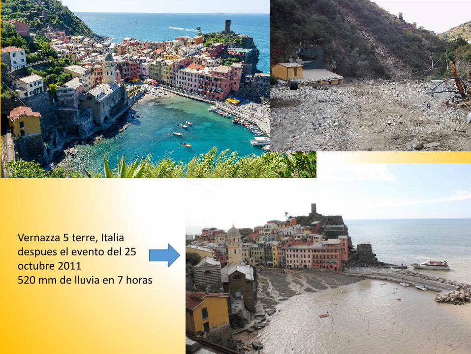
Vernazza 5 terre, Italiadespues el evento del 25 octubre 2011520 mm de lluvia en 7 horas
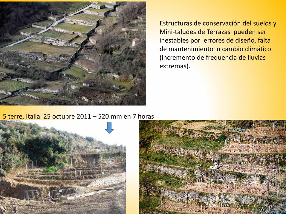
Estructuras de conservación del suelos yMini-taludes de Terrazas pueden ser inestables por errores de diseño, falta de mantenimiento u cambio climático (incremento de frequencia de lluvias extremas).
5 terre, Italia 25 octubre 2011 – 520 mm en 7 horas
Un Herramienta software Freeware de modelado de
inestabilidad , para el diseño de obras de estabilización y
evaluación de condiciones de peligro
El software SSAP 4.7.2 (1991,2016)
WWW.SSAP.EU

SSAP 4.7.2 - WWW.SSAP.EU
Software totalmente freeware , para investigadores, ingenieros, estudiantes Interfaz grafica WIN 10

Combinación de criterio de ruptura en un mismo talud • Mohr –Coulomb cobertura colluvial de suelos residuales • Hoek (2002,2006) – macizo rocosos fracturados y terrazas con megabloques

Generacion automática de superficies de forma generalCon metdod monte carlo y sniff search

Modelado de efecto Estabilizante de un talud inestable Con lineas de palos pilotes en SSAP 4.7.2
Otras estructuras de contenciónAnclajes, reinforced earths, geogridsMuros, gabions.. Etc.

Mapas en coloresCon valores de FS localesY zonas de plasticizacionPosibles
Efectos sísmicos
Metods de calculo riguros LEM:Spencer, Sarma I y II, Janbu rigurosoMorgestern & PriceChen & Morgestern

Mapas de OVER STRESS RATIOQue identifican posiblesorígenes de fenómenos de ruptura progresiva

Mapas de OVER STRESS RATIO
Mapas de OVER STRESS RATIOQue identifican posiblesorígenes de fenómenos de ruptura progresiva

Estucturas composita de contencion

Verifica Estructuras de dique en el Rio Po
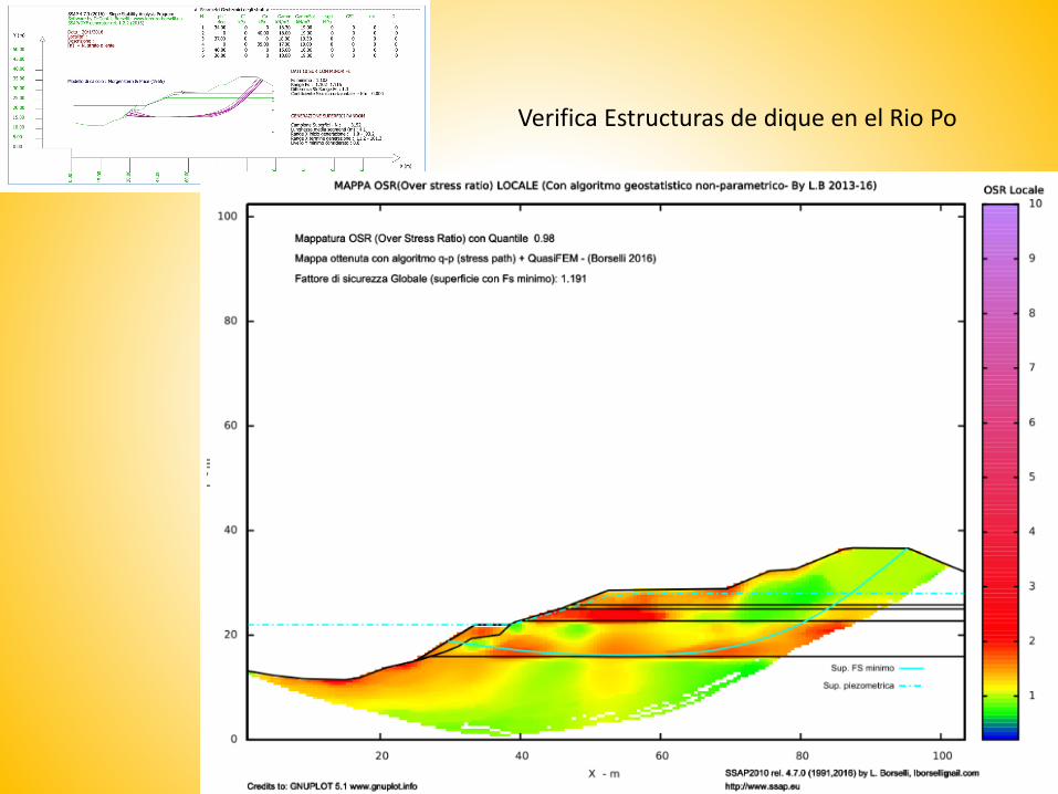
Verifica Estructuras de dique en el Rio Po

Acuifero temporal colgado, que ha disparado mudflow , Sicilia Italia 2014

Acuifero temporal colgado que dispara mudflow , Sicilia Italia 2014
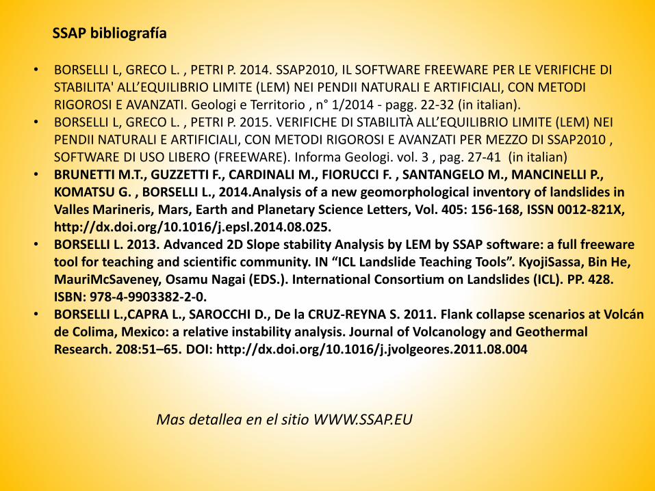
SSAP bibliografía
• BORSELLI L, GRECO L. , PETRI P. 2014. SSAP2010, IL SOFTWARE FREEWARE PER LE VERIFICHE DI STABILITA' ALL’EQUILIBRIO LIMITE (LEM) NEI PENDII NATURALI E ARTIFICIALI, CON METODI RIGOROSI E AVANZATI. Geologi e Territorio , n° 1/2014 - pagg. 22-32 (in italian).
• BORSELLI L, GRECO L. , PETRI P. 2015. VERIFICHE DI STABILITÀ ALL’EQUILIBRIO LIMITE (LEM) NEI PENDII NATURALI E ARTIFICIALI, CON METODI RIGOROSI E AVANZATI PER MEZZO DI SSAP2010 , SOFTWARE DI USO LIBERO (FREEWARE). Informa Geologi. vol. 3 , pag. 27-41 (in italian)
• BRUNETTI M.T., GUZZETTI F., CARDINALI M., FIORUCCI F. , SANTANGELO M., MANCINELLI P., KOMATSU G. , BORSELLI L., 2014.Analysis of a new geomorphological inventory of landslides in Valles Marineris, Mars, Earth and Planetary Science Letters, Vol. 405: 156-168, ISSN 0012-821X, http://dx.doi.org/10.1016/j.epsl.2014.08.025.
• BORSELLI L. 2013. Advanced 2D Slope stability Analysis by LEM by SSAP software: a full freewaretool for teaching and scientific community. IN “ICL Landslide Teaching Tools”. KyojiSassa, Bin He, MauriMcSaveney, Osamu Nagai (EDS.). International Consortium on Landslides (ICL). PP. 428. ISBN: 978-4-9903382-2-0.
• BORSELLI L.,CAPRA L., SAROCCHI D., De la CRUZ-REYNA S. 2011. Flank collapse scenarios at Volcán de Colima, Mexico: a relative instability analysis. Journal of Volcanology and GeothermalResearch. 208:51–65. DOI: http://dx.doi.org/10.1016/j.jvolgeores.2011.08.004
Mas detallea en el sitio WWW.SSAP.EU
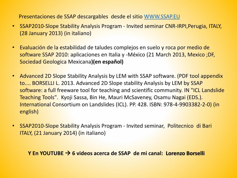
• SSAP2010-Slope Stability Analysis Program - Invited seminar CNR-IRPI,Perugia, ITALY, (28 January 2013) (in italiano)
• Evaluación de la estabilidad de taludes complejos en suelo y roca por medio de software SSAP 2010: aplicaciones en Italia y -México (21 March 2013, Mexico ;DF, Sociedad Geologica Mexicana)(en español)
• Advanced 2D Slope Stability Analysis by LEM with SSAP software. (PDF tool appendixto.... BORSELLI L. 2013. Advanced 2D Slope stability Analysis by LEM by SSAP software: a full freeware tool for teaching and scientific community. IN "ICL LandslideTeaching Tools". Kyoji Sassa, Bin He, Mauri McSaveney, Osamu Nagai (EDS.). International Consortium on Landslides (ICL). PP. 428. ISBN: 978-4-9903382-2-0) (in english)
• SSAP2010-Slope Stability Analysis Program - Invited seminar, Politecnico di Bari ITALY, (21 January 2014) (in italiano)
Presentaciones de SSAP descargables desde el sitio WWW.SSAP.EU
Y En YOUTUBE 6 videos acerca de SSAP de mi canal: Lorenzo Borselli
Gracias por su atención !!!