


![Gustavo Velez gustavo@gavd.net 11-11-2010. Gustavo Velez [MVP SharePoint] gustavo@gavd.net.](https://static.fdocumento.com/doc/165x107/54d01f7a4979592e558b4674/gustavo-velez-gustavogavdnet-11-11-2010-gustavo-velez-mvp-sharepoint-httpwwwgavdnet-httpgeeksmsblogsgvelez-gustavogavdnet.jpg)


Idiomas
Páginas
Jurídico


55
REV. GEO. SUR 2: 55-71
FEDERICO IGNACIO ISLA 1 1 & GUSTAVO 2
1
r
phenomena) or episodes (
during summertime between 2001 and 2007. These thermoclines’ depths were shallower than
in Argentina and Chilean IX- Region) are recording increases in their temperature with depth. In
libres de hielos (interglaciales). Estudios climáticos deben basarse en su analogía con los

56
episódicos (
termoclinas fueron menores que las registradas en el verano de 1984. Los lagos del distrito
en profundidad. En algunos lagos se han registrado plumas de turbidez que seguramente condicionan el registro sedimentario.
geological variations. Their sediments
annual and interannual variations. Global programs are interested in South American
EcosystemsAlthough some international programs are
III) or Europe (). These paleolimnological
studies also assume that these lakes
studies stated that ENSO events are
Ariztegui et al. 2007).
former piedmont glaciers spanning from 38
to 55 degrees south ( Pleistocene
leaving terminal moraines that blocked extended lakes when glaciers receded. This simple scheme could not be applied to all lakes as there are differences assigned
(Bertrand et al. 2008). In regard to the
plutonic areas are more resistant to
watersheds. As the Andes Cordillera is an obstacle to water vapour transported
other extend in the direction of the dominant
are smaller and close to the mountains;
differences between each arm (Nahuel
there are processes that are not quite
57
volcanic district (Caviahue or Agrio) have a chemical conditioning (Gammons et al.
or seiches. The summer thermocline is
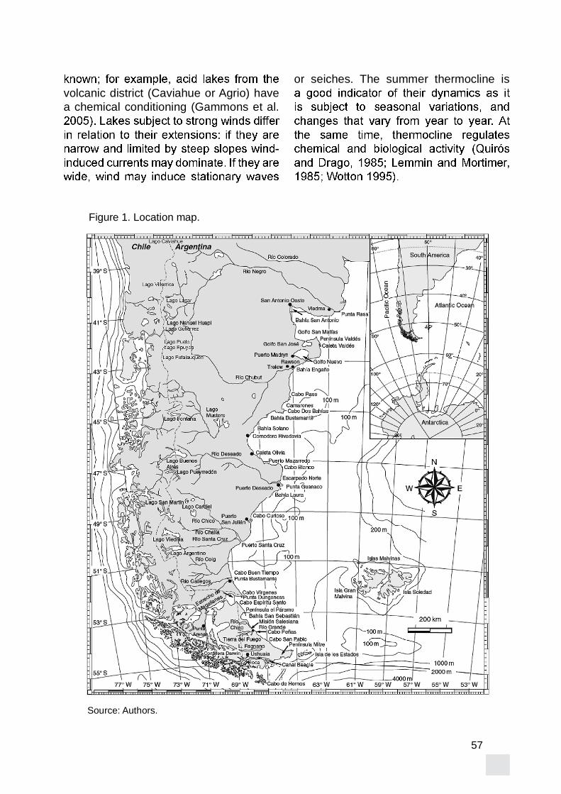
Source: Authors.
Figure 1. Location map.

58
ENSO positive climatic phases cause
these phenomena (Bello et al 2004; Compagnucci and Araneo 2007). Even estuaries of Atlantic watersheds are
ENSOs of 192-83 and 1997-98 (Camilloni 2005; Isla 2008). The ENSO of 1997-98 triggered changes in climatic variables and fauna distribution to latitudes up to 62º
piedmont lakes although their impacts in depth have been matter of little concern.
The present paper describes and
characteristics of some piedmont lakes of
Argentina and Chile ( ). These lakes are located from 38 to 55° S and their
here describe in order to interpret their
response to climatic impacts.
are lakes of low (oligotrophic < 30 g C /m2/
(mesotrophic; 25-60 g C /m2
2/
2
lakes of Patagonia and Tierra del Fuego
mesotrophic with eutrophic areas close to
but in response to wind stress. Several
certain morphometric characteristics lakes and their watersheds ( ).
Lat Area Zmax R DateCAV 37 1650 9.22 570 95 51 22 V 5FEB02ALU 38 1125 57 3956 165 69 V 23JAN07VIL 39 220 185 20967 165 120 53 V 25JAN01LAC 40 625 49 8134 277 166 58 5.8 1048 G 21JAN01GUT 41 750 16.4 1307 111 80 25 G 1FEB02
42 150 44 4902 180 111 57 1 3040 G 19JAN0342 250 17.4 1608 148 92 33 3.6 506 G 18JAN04
FUT 43 518 44.6 4510 168 101 72 0.94 2920 G 18JAN03FAG 54 22 580 46806 200 81 230 24-25 G/T 19FEB03ROC 55 4 5.5 30 G/T 6MAR02
Lat (degrees); Alt (m over MSL); Area (km2); Volume (hm3); Maximum depth (m); meand depth (m);
Source: Authors

59
Araucarias ( . As it occupies the depression of the caldera
dominate in the surroundings. Two levels producing thermal water are located at 800-1000 and 1400 m below ground
interpretations assure that there was a unique Pleistocene glaciation without evidences of glaciolacustrine deposits
reducing bacteria and methanogenic bacteria were sampled from the bottom
site was located in front of the Caviahue village.
is also located within a region dominated
to the east (Pucón village) and to the west (Villarrica village). Pucón receives more
point was located towards the Villarrica
bottom (Moernaut et al. 2009).
Lacar LakeThis lake is located within the Lanín
National Park in a watershed between ranges of 1600 to 1900 m above MSL. Although its maximum area is in the
is a narrow lake of 27.4 x 3.2 km. Granites and diorites (Huechulafquen formation;
during Pleistocene. The watershed is
stable inhabitants. In the neighbourhoods Libocedro chilensis
dominates. The lake was considered as
1964; Pedrozo 1998).
Gutierrez Lake
(Los Machis formation; González Díaz
piroclastic (Andesitic series) rocks are
coihue (Nothofagus dombeyii lenga

60
( ciprés (chilensisare ñire ( retamo (
palo piche (maitén (Maytenus boaria) and bambú(
its southwestern extreme.
(Piltriquitrón formation). Rains reduce from 3000 mm at the international border to 500 mm to the east. and Nothofagus
during the summer. The lake is within the Lago Puelo National Park. Although the urban growth of El Bolsón and Lago
the photic zone extends to depths of 25 m. Oligotrophic conditions persist even in the north shore where the sampling was conducted (Azul River inlet).
glaciers but the ice eroded these glacial during the Pleistocene. Plutonic (Tonalita del Platero formation; Cazau 1980) and vulcaniclastic rocks extend to the
ranges. Glaciolacustrine deposits have
(Caldenius 1932; Isla and Espinosa 2008). The lake was found ultraoligotrophic in the
can be distinguish at the depths lower than 20 m. Fishing logs and industries related
shore. Several samplings were conducted at different parts of the lake.
It is located in the middle of a complex
River collects water from the Rivadavia
and metamorphic (Cushamen formation; Esquistos de Esquel) and plutonic rocks dominate in the surroundings. Two thirds of this watershed is under the Los Alerces
inhabitants are stable although in summer
an incipient cattle (cows and sheeps)
during the summer. Secchi depths can
reaching lower depths during winter
been recognized in the region (Caldenius 1932) pointing to ancient levels of 735 m over MSL. The site of measurements was located towards the south of the lake.
Fagnano Lake
in the centre of the Grande Island of Fueguian Archipielago. Elongated with an
Azopardo River. The watershed is covered
guindo dominating to the southern slope

61
of the ranges. The lake receives several
to the headlands as the area is of the same order of magnitude of the drainage
Scotia plates. Low-grade metamorphic
peat bogs dominate the basin. The lake is considered ultraoligotrophic due to high
contents (Mariazzi paleolake has been described as reaching levels 18-21 m over present Fagnano Lake
1997). Sampling was conducted in the middle of the lake in front the settlement of the coastguards.
over MSL between the ranges of Valdivieso and de las Pirámides. It receives water
Channel) within the Tierra del Fuego National Park. High-grade metamorphic rocks (Lapataia formation; Borrello 1969)
Sphagnumthe depressions between forests of lenga and coihue. The input of suspended
glaciers met the Beagle Channel before the maximum Holocene highstand melted them. Sampling was conducted at the SE
Beagle Channel.
1981 and Hakanson and Jansson 1995) were estimated. Data was collected
response to the attenuation of an infrared light.
Range UnitspH 0-14 Adimensional
0-1 MS/cm0-800 1 NTU
Mg/lTemperature 0-50 º C
0-4 % Source: Authors
62
measurements were collected in different
that were related to their different
CAVIAHUE (CAV)
(Fig. Similar results were obtained in 2000
with cold temperatures of about 5 ºC below
was 5.3 indicating acid waters related to the Copahue volcano at the surroundings.
below 18 m depth. DO was lower than 1
species.
6 m. Surface temperatures were around 18 º C changing to 16 º C below this
temperature increased to 18 º C at 26 m depth. This behaviour was assigned
Villarrica Volcano. PH is also probing these volcanic effects (pH 7.8) although at surface pH water was 9 DOpresented high levels (between 10 and 12 mg/l).
Lácar is an oligotrophic lake that
los Andes. Temperature drops in depth from 17 º C at surface to 13º C below the thermocline. PH maintained stable
were recorded increased with depth from 8 to 11 mg/l.
a thermocline at depths of 16-18 m. PH was also stable between 10 and 10.5. A
and 13 m depth. DO was also uniform with levels approaching 4 mg/l .
of the inlet of the Azul River in the lake. Temperature was uniform about 15-16º C
. PH was stable betwen 10 and 11.
21 and 26 m assigned to the effects of the river inlet. DO was stable around 6 mg/l.
m depth; 18º C were measured at surface and 13º C about 26 m depth. PH was stable around 8.3
(Fig. 4).
At the upper 26 m this lake was uniform with a temperature of 15º C. PH increased with depth from 9.5 to 10 at 17 m depth. As this lake is rather deep and receiving water
detected
temperature is uniform in depth between 10 and 11º C. PH is also uniform at 8.
reduced from 5.6 to 4.6 mg/l in depth (Fig.

63
It has a uniform temperature of 10º C
a slight decrease to 14 m depth. Several
and 20 m depth; below 22 m depth it is transparent again. DO diminished in depth from 4 to 2.6 mg/l.
Figure 2. Vertical variations in temperature (°C)
Figure 3. Vertical variations in pH.
Figure 5. Vertical variations of Dissolved.oxigen (mg/l).
between depths of 8 and 12 m due to
was recorded. Temperature vertical variations of the Villarrica and Caviahue
Fig.). Thermoclines detected in the lakes
between 2001 and 2004 were shallower

64
than those measured in 1980 in the same
LAC) are more acid. PH increased to the south to maximum values of 10 (Fig. 3).
16 m (Fig. 4
Lakes of Northern Patagonia (Villarrica and Lácar) reported higher values of
Fig. 5the Lácar Lake explained this increase in
(within tall mountains) that communicate
FUT and ROC).
Intra and Inter-hemispheric comparisons
Locations of the summer termocline
reported for the summer-autumn Fig. 6). In those
explained in response to the fetch each
1985). Considering slight differences in the
Argentine lakes have lower temperatures
located north of 42º S.
Lakes respond to the climatic changes
the effects of the ice balance. Considering glaciers draining the South Patagonia
12 and 20 m at latitudes of 46-47° N
upper 26 m. These differences can be
northern lakes located to the east of the
therefore less turbulent in their upper
thermocline. Southern lakes are located
of the energetic westerlies. A monitoring
1995) could explain more about thermocline
differences of several decimetres were measured at the Fagnano Lake (J. L.

65
Climatic effects
lakes based on the diatom content in sediments have been related to global
variations in Patagonian lakes. For
2008). The Perito Moreno Glacier (Santa
ENSO interannual events and therefore impacting on the Argentino Lake (Depetris
Tronador Arm of the Mascardi Lake (Río
sedimentation rate that was also attributed to ENSO effects (Villarosa
Source: Authors.
Figure 6. Depth of the thermocline according to latitude in 1984 and those measured
strong ENSO positive phase that produced an increase in mudslides (Trauth et al.
were reported to contain an ENSO signal related to wet periods (Eden and Pages
previous references provided from tree
condition thermocline depths and therefore
seasonal variations (summer-winter) but
2008).
Patagonian lakes are of special interest
that also permitted the preservation of glaciolacustrine sequences. End

66
watersheds. These glaciated watersheds that drained towards the Atlantic Ocean
Ocean when the glaciers receded (water
towards the Atlantic Ocean lost their recharge areas (21-24 %) and recharge volumes (33-34%) delivering less water to the Patagonian desert and therefore
Lake began to drain via the Huahum river;
lake via the Azopardo River. These
watersheds facilitated the preservation of glaciolacustrine deposits corresponding
lakes.
Episodic effects
Lakes from the volcanic district are
Moernaut et al. 2009). In Icalma Lake
or sub-lacustrine slides are assumed to trigger seiches that produced chaotic
lake received an ash deposit about
earthquakes of 1960 were reported from
Huapi (Villarosa et al. 2007). Southern Patagonia lakes are also assumed to be
(Stern 1990).
Andean lakes of Northern Patagonia are 1.
between 10 and 22 m. These values are shallower than those measured in 1984. As there is not a monitoring
can be assigned either to a warming
being the more probable.2.
lakes.3.
recorded within the Volcanic District (lakes Caviahue and Villarrica) showing
4.
26m.5.
and 10.5.These characteristics of present lakes 6.should be considered when interpreting ancient deposits that could be related to same watersheds.
Samplings were executed with the help of the coastguards (Prefectura Naval
4383/97). Some results were presented at
J. L. Hormaechea provided unpublished information.

67
161-184.
ENSO frequencies during Little Ice Age (LIA) in Northern Patagonia. The laminated record of proglacial
Late Pleistocene environmental change in Eastern Patagonia and Tierra del Fuego. A limnogeological
Late Cenozoic of Patagonia and Tierra del Fuego. Developments in
Tomo I. Comisión de Estudios Hidrológicos 1911-1914. Ministerio de Obras Públicas. 500 pp.
ENSO 1997-2000 in Central Chile.
M. (2008). Reconstruction of the
the Southern Andes from seismites
Geosinclinales de la Argentina. Anales de la Dirección de Geología
Argentina.
Argentina.
glaciolacustrine sedimentation at
2): 767-778.
del Fuego.14:1-164. Stockholm.
tendencias hidrológicas en la
El

68
D. C. (2007). Alcances de El Niño como predictor del caudal de los ríos andinos argentinos. Ingeniería
(2): 111-150.
the Perito Moreno glacier damming of Lake Argentino (Southern Andean Patagonia): The connection to climate anomalies.
Patagónicos. Su relación con los
Universidad Nacional de Buenos Aires.
lakes of differing trophic status (Argentina). Hydrobiologia 369/370: 45-57.
Chemical composition and the nitrogen-regulated trophic state of Patagonian lakes. Limnologica 17–27.
Palaeoclimatic implications of a storm erosion record from Late Holocene
249-267.
mine drainage. Mining Engineering,
(2006). The acidic waters of Río Agrio and Lago Caviahue at Volcán
englazamiento de la región de la caldera de Caviahue-Copahue (Provincia del Neuquen): su reinterpretación.
58(3): 356-366.
(1980). Cuenca Neuquina. Academia
1099-1147.

69
p.
.
estuaries of Buenos Aires: The interannual transfer of water from
Ciclicidad de los depósitos
(1986). Tests of an extension to internal seiches of Defant´s prcedure for determination of surface seiche characteristics in real lakes. Limnology and Oceanography 31 (6): 1207-1231.
effects of thermal manipulation
Hydrology and Earth
3357–3394.
America. Glaciers of Chile and
1206.
and prospectus. Earth-Science
1987. Limnological investigation in
of buried mass-wasting deposits in lake sediments and its relevance
Central Chile).
57 (2): 182-194.

70
Informe Plan de Muestreo de la
Lago Lacar. Informe Universidad
Martín de los Andes.
(1993). Chemical composition of nutrient limitation in river and lakes of
-42 S; 71
25: 207-214.
el riesgo volcánico en la Argentina. Ciencia Hoy 60: 46-58.
Impacto Ambiental producido por una Salmonicultura en fase experimental
. Nº 18. Marzo de 1991.
of the Ice Age on the continental watershed of Patagonia.
University of Upsala92.
Chubut (Argentina).
Instituto Nacional de
(INIDEP). 48 pp.
factibilidad de uso del Lago Fagnano (Tierra del Fuego) para la cría de
Verh. Internat. Verein. Limnol. 23: 647-658.
continentales de la República
Contribución 435, Instituto Nacional
de Ciencias Naturales del Litoral.
Naturales del Litoral 16(2):181-199.
Diatom shifts as evidence for recent Subarctic warming in
Canada.
warming in lakes from the northern

71
southernmost Patagonia. National
126.
M. R. (2003). Multiple landslide
changes in the northwestern Argentine Andes.
en las tasas de sedimentación como indicadores de episodios climáticos
Nacional Nahuel Huapi.
Estudio sobre el origen del tsunami
Evaluación de peligrosidad. Informeinédito
el sur de Chile.
and lake-outlet communities.
Top Related