


Idiomas
Páginas
Jurídico

Información generalÁrea de Interés
Límites administrativosInternational Boundary
Asentamientos! Lugar poblado
Zona edificadaHidrología
RíosArroyoLagos
FisiografíaCurvas de nivel y elevación (m)
Transportes!
r
AeródromoCarretera PrimariaCarretera SecundariaCarretera Local
!
r
!
r
!
r
!
r
!
!
!
!
!
!
!
!
!
!
!
!
!
!
!
!
!
!
!
!
Lago Ranco Laguna Verde
Laguna Pichi
Lago Maihue
Laguna Pocura
LagoHuishue
RíoBueno
RíoCu
rrinhu
e
RioRiñinahue
Río Calcurrupe
Río Huinahue
Río IgnaoRioNilahue
RíoPilla nle ufu
Coique
LasBandurriasAirport
LlifenCalcuruppe
Airport
LoncopanAirport
Cruce T-55 (Llifen)- Arquilhue
PuenteNilahue
Balmaceda
Concepcion
Calcurru pe - Llifen
Río Bueno -Lago RancoLago Ranco - Calcurrupe
Coique
-
Puerto Nuev
o
Cruce Ruta T-39 (Los
Lagos) - Futrono - Llifen
Lacar
Los Lagos
Valdivia
Neuquen
Los Lagos
Ignao
Nontuela
Loncopan
San Pedro
Dollinco
Bahía Coique
PuertoLas
Rosas
Ilihue
Llifén
Caunahue
Huequecura
Riñinahue
VásquezPuertoLosLlolles
Arquilhue
Los Guindos
Rupumeica
Lago Ranco
Futrono
900600
1200
900
900600
300
1200900
600
300
900
300
15001200
1500
1200
15001200
900
600
900600
600300
600
300
1500
1200
600
1500
1200
1500
1800
1500
1200
1500
1500
900
1200
1200
1200
1200
900
1200
600
900
600
1500
1800
1800
1800
1800
1800
1200
1200
1200
1500
1500
1200
1200
1500
1500
1500
1500
1500
1500
1500
1500
1500
1500
1500
1500
1200
900
900
1200
120012001200
900
900
900
900
300300
600
600
300
300
300
900
900
900
600
600
600
600
600
600 600600
600
300
300
300
300
300
300
300
300300
300
300
71°50'0"W
71°50'0"W
71°55'0"W
71°55'0"W
72°0'0"W
72°0'0"W
72°5'0"W
72°5'0"W
72°10'0"W
72°10'0"W
72°15'0"W
72°15'0"W
72°20'0"W
72°20'0"W
72°25'0"W
72°25'0"W
72°30'0"W
72°30'0"W40
°0'0"
S
40°0
'0"S
40°5
'0"S
40°5
'0"S
40°1
0'0"S
40°1
0'0"S
40°1
5'0"S
40°1
5'0"S
40°2
0'0"S
40°2
0'0"S
40°2
5'0"S
40°2
5'0"S
710000
710000
720000
720000
730000
730000
740000
740000
750000
750000
760000
760000
770000
770000
5520
000
5520
000
5530
000
5530
000
5540
000
5540
000
5550
000
5550
000
5560
000
5560
000
5570
000
5570
000 Número GLIDE: WF-2016-000138-CHL
!(
Neuquén
RíoNegro
Araucanía
LosLagos
Lago
Llanquihue
LagoRanco
LagoNahuelHuap
LagoRupanco
SOUTHPACIFICOCEAN
Futrono
Limay
0201 Argentina
Bolivia BrazilParaguay
Peru
Chile
SOUTHPACIFICOCEAN
SOUTHATLANTIC
OCEAN
Scotia Sea
Santiago
Información geográfica
1:100000
±Rejilla de referencia: WGS 1984 UTM Zone 18S sistema de coordenadas del mapa
Full color ISO A1, resolución media (200 dpi)
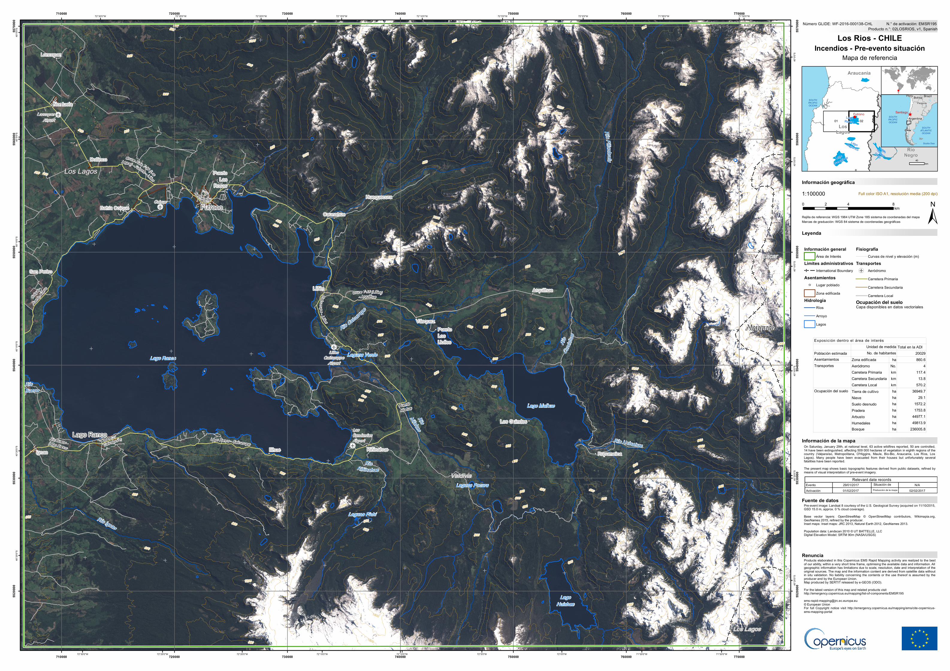
On Saturday, January 29th, at national level, 63 active wildfires reported, 50 are controlled,14 have been extinguished, affecting 509 000 hectares of vegetation in eighth regions of thecountry (Valparaíso, Metropolitana, O'Higgins, Maule, Bio-Bio, Araucanía, Los Ríos, LosLagos). Many people have been evacuated from their houses but unfortunately severalfatalities have been reported.The present map shows basic topographic features derived from public datasets, refined bymeans of visual interpretation of pre-event imagery.
Products elaborated in this Copernicus EMS Rapid Mapping activity are realized to the bestof our ability, within a very short time frame, optimising the available data and information. Allgeographic information has limitations due to scale, resolution, date and interpretation of theoriginal sources. The map and the information content are derived from satellite data withoutin situ validation. No liability concerning the contents or the use thereof is assumed by theproducer and by the European Union.Map produced by SERTIT released by e-GEOS (ODO).For the latest version of this map and related products visithttp://emergency.copernicus.eu/mapping/list-of-components/[email protected]© European UnionFor full Copyright notice visit http://emergency.copernicus.eu/mapping/ems/cite-copernicus-ems-mapping-portal
Leyenda
Marcas de graduación: WGS 84 sistema de coordenadas geográficas
Producto n.°: 02LOSRIOS, v1, SpanishN.° de activación: EMSR195
Pre-event image: Landsat 8 courtesy of the U.S. Geological Survey (acquired on 11/10/2015,GSD 15.0 m, approx. 0 % cloud coverage).Base vector layers: OpenStreetMap © OpenStreetMap contributors, Wikimapia.org,GeoNames 2015, refined by the producer.Inset maps: Inset maps: JRC 2013, Natural Earth 2012, GeoNames 2013.Population data: Landscan 2010 © UT BATTELLE, LLCDigital Elevation Model: SRTM 90m (NASA/USGS)
0 4 82km
Los Rios - CHILEIncendios - Pre-evento situación
Mapa de referencia
Relevant date recordsEvento Situación de29/01/2017 N/AActivación Producción de la mapa01/02/2017 02/02/2017
Renuncia
Fuente de datos
40km
Ocupación del sueloCapa disponibles en datos vectoriales
Total en la ADIPoblación estimada 20029Asentamientos Zona edificada ha 860.6
Aeródromo No. 4Carretera Primaria km 117.4Carretera Secundaria km 13.8Carretera Local km 570.2Tierra de cultivo ha 36949.7Nieve ha 29.1Suelo desnudo ha 1572.2Pradera ha 1753.8Arbusto ha 44977.1Humedales ha 49813.9Bosque ha 236005.8
Expos ic ión dentro el área de interésUnidad de medidaNo. de habitantes
Transportes
Ocupación del suelo
Información de la mapa
Top Related